Lake Bob Sandlin
Lakes in the East Texas Area
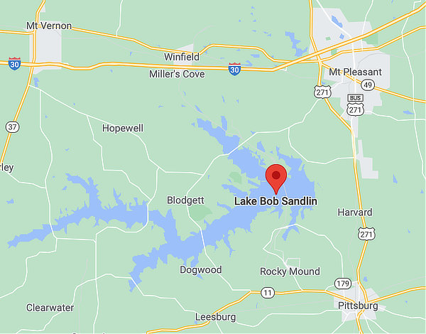
 Map showing the location of Lake Bob Sandlin |
In East Texas, there are over 50 lakes offering a variety of outdoor sports for vacations or weekends. These lakes provide fishing, swimming, water skiing, houseboats, jet skis, sailing and other outdoor and hiking activities.
Within easy driving distance are lakes such as Toledo Bend Reservoir, Wright Patman, Lake Fork, Sam Rayburn, Lake Tawakoni, Caddo Lake and many others..
Lake Bob Sandlin
Lake Bob Sandlin is located on Big Cypress Creek 5 miles southwest of Mount Pleasant in Titus, Camp, and Franklin counties. The City of Pittsburg is located to the southeast of the lake.
It has a surface area of 9,004 acres, and a maximum depth of 65.6 feet. It was impounded in 1977.
The lake features 75 miles of shoreline. The lake was named in honor of its major proponent, local businessman, civic leader, and Titus County Fresh Water Supply District No. 1 president Bob Sandlin.
The Fort Sherman Dam is named after the local historic site. First construction of the dam began in 1974. The earthfilled dam was built to a maximum height of 69 feet, a top width of 25 feet, and is 10,800 feet long. A formal ceremony dedicated the lake on June 25, 1978.
Lake Bob Sandlin State ParkLake Bob Sandlin State Park is a 639.8-acre park located on the heavily wooded shoreline on the north side of Lake Bob Sandlin. This lakeside park offers fun on water and land. Swim, fish, paddle and boat on the lake. Or picnic, hike, camp, geocache, mountain bike and nature watch under the trees. Visit in autumn to see spectacular fall foliage. Fish in the lake from shore, pier or boat. Or try your luck at the stocked Trout Pond or Brim Pond. Anglers here catch largemouth bass, catfish and crappie. The park has a boat ramp, a lighted fishing pier and a fish cleaning station. It loans fishing poles and rent kayaks for use in the park. The park has 3.3 miles of wooded trails for biking or hiking. Choose from 75 campsites with water and electricity, or set up a tent at a primitive campsite. Cabins or screened shelters are also available. The park is located approximately 12 miles southwest of Mt. Pleasant on FM 21. Exit Interstate 30 on Highway 37 South at Mt. Vernon. Go .8 mile; turn left on Highway 21; go 11.2 miles to the park entrance. Visitors can make reservations for facilities at the State Park online, or phone 512.389.8900
|
Fishing Lake Bob Sandlin
Predominant Fish Species in Lake Bob Sandlin
- Spotted bass
- Catfish
- Crappie
- Largemouth bass
- Bluegill
Angling Opportunities at Bob Sandlin
Lake Bob Sandlin offers many quality options when pursuing sportfish. The largemouth bass population is moderately abundant with good numbers of legal-size fish available for harvest.
Spotted bass are present but at low densities. White bass is a popular species with high numbers of quality size fish. Channel catfish in recent years have become more abundant across all size classes, and there are plenty of good-sized fish available for harvest.
Good numbers of legal size crappie are present and provide good fishing opportunities. Redear sunfish, the dominant sunfish species in the lake, are moderately abundant and also showing good sizes.
Fishing Cover/Structure
Natural habitat is present in the form of inundated timber and aquatic vegetation. There are also numerous boat docks and fishing piers. There are 6 artificial fish habitat sites on this lake. Anglers may use GPS in conjunction with a fish finder to locate these structures
Map of Lake Bob Sandlin

Lake Bob Sandlin Water Level: Conservation Pool Elevation is 322'
Courtesy of the U.S. Geological Survey
Nearby Mount Pleasant
Located about 80 miles northeast of Tyler on U.S. Highway 271 at its intersection with U.S. Highway 67 and Interstate I-30 is the City of Mt. Pleasant, the county seat of Titus County.
The population of Mt. Pleasant is about 16,000 residents as of the 2020 Federal Census. Elevation is 404 feet above sea level.
The City of Mount Pleasant was selected by the Texas Historical Commission to become an official Texas Main Street City in 1993 and has been a Nationally Recognized program since 2010.
Mount Pleasant has grown and prospered over the past 100 years. Its location along primary transportation routes such as I-30 and the new State Highway 271 Loop, as well as a strong independent attitude of the population has furthered that growth. Today, 32,000 people call Mount Pleasant & Titus County home. They work in what is the hub of a five county region. In addition to being a regional employment center, Mount Pleasant also offers quality retail shopping with a 2018 retail trade area of 106,000 persons.
The Mount Pleasant Main Street District is a 42- block area located in the central business district of downtown Mount Pleasant.
Read more about Mount Pleasant
Mt. Pleasant Area Hotels and Accommodations
Lake Bob Sandlin on YouTube ... uploaded by Texas Parks & Wildlife |
Lake Bob Sandlin Area Resources
- City of Mount Pleasant
- Visit Mount Pleasant
- Mount Pleasant/Titus County Chamber of Commerce
- Lake Bob Sandlin State Park at Texas Parks and Wildlife
- Mount Pleasant Economic Development Corporation
- Titus County
- Titus County Fresh Water Supply District No. 1
- Barefoot Bay Marina
- Texas Freshwater Lakes provided by Texas Parks and Wildlife


